By
With Muni service temporarily reduced during the COVID-19 health crisis, many San Francisco residents need to walk and take other modes of transportation to make essential trips. However, sometimes it is difficult to maintain 6’ of social distance on many sidewalks, park paths, and bikeways. This can be especially true when passing lines outside grocery stores and other essential services. Because of this, many pedestrians are choosing to walk in the street, exposing themselves to swiftly moving vehicle traffic. The SFMTA is implementing a new program, Slow Streets, to close some streets to through traffic and allow roadways to be used more as a shared space for foot and bicycle traffic.
Throughout the city, corridors have been identified for Phase 1 Slow Streets. Beginning this week, some of these streets will be closed to through vehicle traffic to prioritize walking/biking and to provide more space for social distancing during essential travel by those modes.
What Will Slow Streets look like?
Vehicle traffic will be allowed, and streets will not be closed completely, local access to vehicles is allowed, (e.g. driveway access for residents.) Slow Streets will not create any legal change in the right of way. People walking/running in the street will not have the right-of-way over motor vehicles but will be allowed to be in the street (as the Calif. Vehicle Code currently permits). The goal is to take advantage of low vehicle numbers on certain travel corridors and allow people to maximize our resources while maintaining social distancing. Slow Streets will be in effect 24/7, given the limited staff resources to deploy/re-deploy equipment daily.
The purpose of Slow Streets is to manage traffic speeds and create a safe network for essential walk and bike travel while transit service levels are reduced. Our agency is committed to giving San Franciscans the necessary space to practice social distancing as they leave their homes for critical needs.

Slow Streets candidates
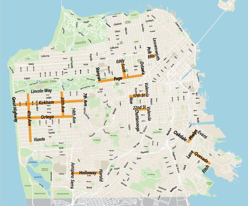
- Good candidates for a first phase of Slow Streets are shown on the map and in Table 1. These are lower-traffic residential streets that connect neighbors to essential services in the absence of Muni service. They have been vetted for feasibility and exclude Muni routes and major emergency traffic corridors.
- For most Slow Streets, rollout will be incremental and iterative - approximately 8 blocks at a time - and may not initially cover the entire length shown on the map. Careful monitoring will be provided to ensure the transportation benefits of Slow Streets are not undermined by crowding and congregation.
| Street | From | To | Muni Routes |
| 17th Street | Noe | Valencia | 22 Fillmore, 33 Stanyan |
| 20th Avenue | Lincoln | Ortega | 28 - 19th Ave |
| 22nd Street | Valencia | Chattanooga | 48 Quintara |
| 41st Avenue | Lincoln | Vicente | 18 - 46th Ave |
| Ellis | Polk | Leavenworth | 27 Bryant, 38 Geary |
| Holloway | J Serra | Harold | K Ingleside, 29 Sunset |
| Kirkham | Great Highway | 7th Avenue | N Judah |
| Phelps | Oakdale | Evans | 23 Monterey, 44 O'Shaughnessy |
| Ortega | Great Highway | 14th Avenue | 7 Haight |
| Page | Stanyan | Octavia | 7 Haight |
| Quesada | Lane | Fitch | 23 Monterey, 44 O'Shaughnessy |
| Scott | Eddy | Page | 24 Divisadero |
When will these streets be closed?
Beginning this week, we hope to install 2-3 Slow Streets corridors per week. Signage and traffic cones for the first round of streets. We will continue to monitor the use of Slow Streets to minimize impacts on surrounding streets.
How were the Slow Streets corridors chosen?
The streets were chosen to supplement reduced or suspended Muni routes, while providing bicycle and pedestrian access to essential services. Many of these streets run parallel to other major streets and transit routes. The Slow Streets are intended to provide a network of streets that prioritize walking and biking for essential trips.
Slow Streets are one part of the city’s efforts to reduce sidewalk crowding. Other efforts include removing vehicle parking outside grocery stores and restaurants to create extra pedestrian queueing space and widening sidewalks by removing vehicle parking on select high-pedestrian-traffic. Please visit sfmta.com/COVID19 for the latest agency updates.
Published April 21, 2020 at 10:13PM
https://ift.tt/3bt1lce
Nhận xét
Đăng nhận xét